About this resource
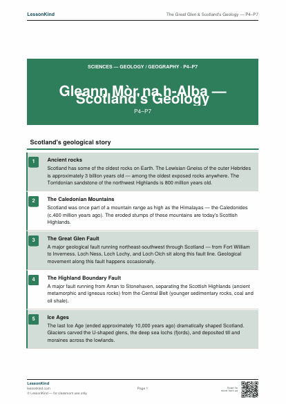
A P4–P7 Science and Geography resource on Scotland's remarkable geology — the Great Glen fault, the Caledonian mountain range, the Highland Boundary Fault, and how geological history shaped the Scottish landscape.
What's included
- Print-ready PDF — A4 and US Letter compatible
- No sign-up required — download instantly
- Free to use in your classroom
More like this
More Science resources

My Five Senses
Match each sense to its body part and to things you can sense with it.

Day and Night
Sort activities into day and night. Introduces the Sun, Moon and Earth's rotation.

Parts of a Plant — Labelling Activity
Label the roots, stem, leaves, flower and seeds of a flowering plant.

Animal Habitats
Match animals to their habitats — desert, ocean, rainforest, polar, grassland.

Materials Sorting Worksheet
Sort objects by their material — wood, metal, plastic, glass, fabric, paper.

Life Cycle of a Butterfly
Sequence the four stages of metamorphosis with descriptions and a labelling task.
This page contains affiliate links. We may earn a commission at no extra cost to you. Full disclosure →
Stay Safe Online with NordVPN
Protect your connection on school networks and at home — trusted by millions. Recommended for teachers and students.
Get NordVPN →